
Diversified landscapes of China
China, the third largest country in the world (after Russia and Canada), is situated in Southeast Asia along the coastline of the Pacific Ocean, bordering 14 countries including Russia, Mongolia in the east, Laos, India, Nepal in the south, Pakistan, Tajikistan in the west, Korea in the northeast and more. Resembling a rooster, China covers an area of 9.6 million square kilometers and a coastline of 18,000 km. (11,185 mi.). It reaches Mohe in Heilongjiang Province as its northern end, Zengmu Ansha (or James Shoal) to the south, Pamirs to the west, and expands to the eastern border at the conjunction of the Heilongjiang (Amur) River and the Wusuli (Ussuri) River.
Geography Features
The diversified landscapes of China include plateaus, plains, basins, foothills and mountains. The mountainous areas occupy nearly 2/3 of the land, higher in the West and lower in the East like a three-step ladder.
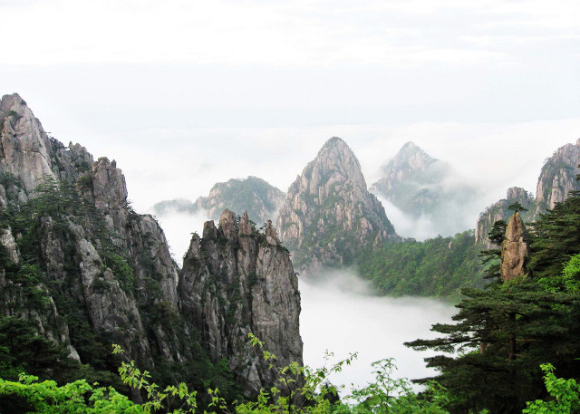
The lowest step in the east region of China are covered by vast plains and dotted with foothills and lower mountains. The Middle-Lower Yangtze Plain is one of the most famous plains in this area, here you can visit Shanghai, Nanjing and Suzhou. The famous scenic spots in this area include Mount Huangshan, and Mount Tai.
On the second step are large basins and plateaus, most of which are 1,000 - 2,000 meters high. The Daxing'an, Taihang, Wu and Xuefeng Mountains divide this step and the next lower one. Plateaus including Inner Mongolian, Loess, Yungui Plateaus, and basins such as Tarim, Junggar, and Sichuan Basins are situated here.

Jiuzhaigou National Park is one of the must see scenic spots in this area. Lying on the highest mesa in the world between the Sichuan Basin and the Qinghai-Tibetan Plateau, it was listed as a UNESCO world heritage site because of the large number of lake groups, waterfalls and rich variety of endangered plants. Other scenic spots include Guilin Li River, Shangri-la and Zhangjiajie National Parl.
The highest step of the typical 'ladder topography' is formed by the Qinghai-Tibet Plateau at the average height of over 4,000 m. (13,123 ft.), with the Kunlunshan range, Qilianshan range and Hengduan mountain chain as the division between this step and the second one. The highest peak in the world, Everest, at 8844 m. (29,016 ft.) high is known as 'the Roof of the World'.
Rivers and Lakes
China is a vast country crisscrossed with numerous rivers and dotted with lakes. Yangtze River, the longest in Asia and the third-longest in the world. Here travelers can enjoy a Yangtze River cruise to capture the breathtaking scenery of the Three Gorges. The Yellow River or Huang he, is known as the 'Mother River of the Chinese People'. It is second in length to the Yangtze in China and located further north. Both of these rivers flow into the Pacific Ocean. Other famous rivers such as Li River are also some must see scenic spots in China.

Lakes are also important. The areas with the most lakes are the Middle-Lower Yangtze Plain and Qinghai-Tibet Plateau. Many lakes in the northwest are salty. Qinghai Lake, a beautiful natural salt-water lake, is the largest. In southeast China, most lakes are fresh water. Poyang Lake, Dongting Lake , and Taihu Lake are all fresh water lakes.
These provide China with precious resources such as aquatic products, petroleum, natural gas, mines and renewable resources including tide power.
Related tours


